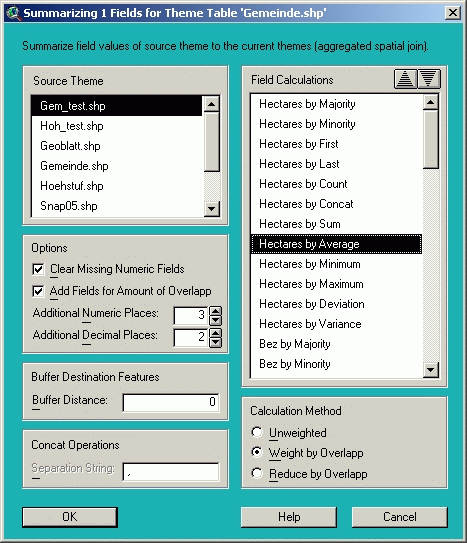
Sum Attributes - Summarize field values of source theme (aggregated spatial join)
With this function you can perform aggregated calculations for several records, i.e. transfer attributes from a source theme to several destination themes by joining the themes spatially (according to the spatial relationship of their features) and by summarizing the field values of all overlapping features (sum, minimum, maximum, majority, standard deviation etc.). This kind of join is only possible between the themes of the active view.
In opposite to the spatial join of ArcView (where only the field value of the first fitting record is used) the field values of all overlapping features are considered with this function. The calculations can be made without priority, weighted by the degree of overlap or reduced proportionally (i.e. the largest area or the longest way inside of the polygon or the nearest situated point have the highest weight). This function is very powerful and of multipurpose use (see Examples of use
below) and there are many differences to a normal spatial join (see Hints to join attributes).The order in which these fields are added can be changed with the following buttons:
Note
: The name of the created fields consists of the first 3 letters of the function name followed by an underscore and the name of the source field (e.g. Min_Area for the minimum value of the field Area, only Minority is abbreviated with Mnr). If the created field names became too long and were truncated, they can be changed with Rename Fields using the alias "A" afterwards.Warning
: The correct choice of the calculation method is crucial for the correctness or the results. Check your data before each calculation carefully though. If you want to calculate fields that depend on areas and fields that are independent, you have to perform the calculation in two separated steps.Weighting factor
: The field values can be weighted or reduced by the degree of overlap. The calculation of this factor and how the features are related and intersected, depends on the type of the source and destination theme ("buffer" stands for a destination theme of any type that is buffered during calculation):|
Source |
Destination |
Condition for overlap |
Weighting factor |
|
Point |
Point |
coordinate is identically |
record number |
|
Point |
Line |
point is exactly on the line |
position along the line |
|
Point |
Polygon |
point is inside of the polygon |
distance to the outline of the polygon |
|
Point |
Buffer |
point is within the buffer |
distance to the outline of the buffer |
|
Line |
Point |
line contains the point exactly |
position along the line |
|
Line |
Line |
lines are overlapping |
length of identical line section |
|
Line |
Polygon |
line is intersecting the polygon |
length of line section within polygon |
|
Line |
Buffer |
line is intersecting the buffer |
length of line section within buffer |
|
Polygon |
Point |
polygon contains the point |
distance to outline of the polygon |
|
Polygon |
Line |
polygon contains part of the line |
length of line section within polygon |
|
Polygon |
Polygon |
polygons are overlapping |
area overlapping with polygon |
|
Polygon |
Buffer |
polygon overlaps the buffer |
area overlapping with buffer |
|
Polygon |
=Source |
polygons are adjacent |
length of the common border line |
Adjacent polygons without overlap are normally not considered. If a polygon theme is joined with itself though (destination theme identical to source theme), the adjacent polygons are included and the length of the common border line is used as weighting factor. Polygons that are only connected at a single point are still ignored. Buffer the features to include those neighbors too.
Examples of use
:© 2003 WLM Klosterhuber & Partner OEG